About this walk
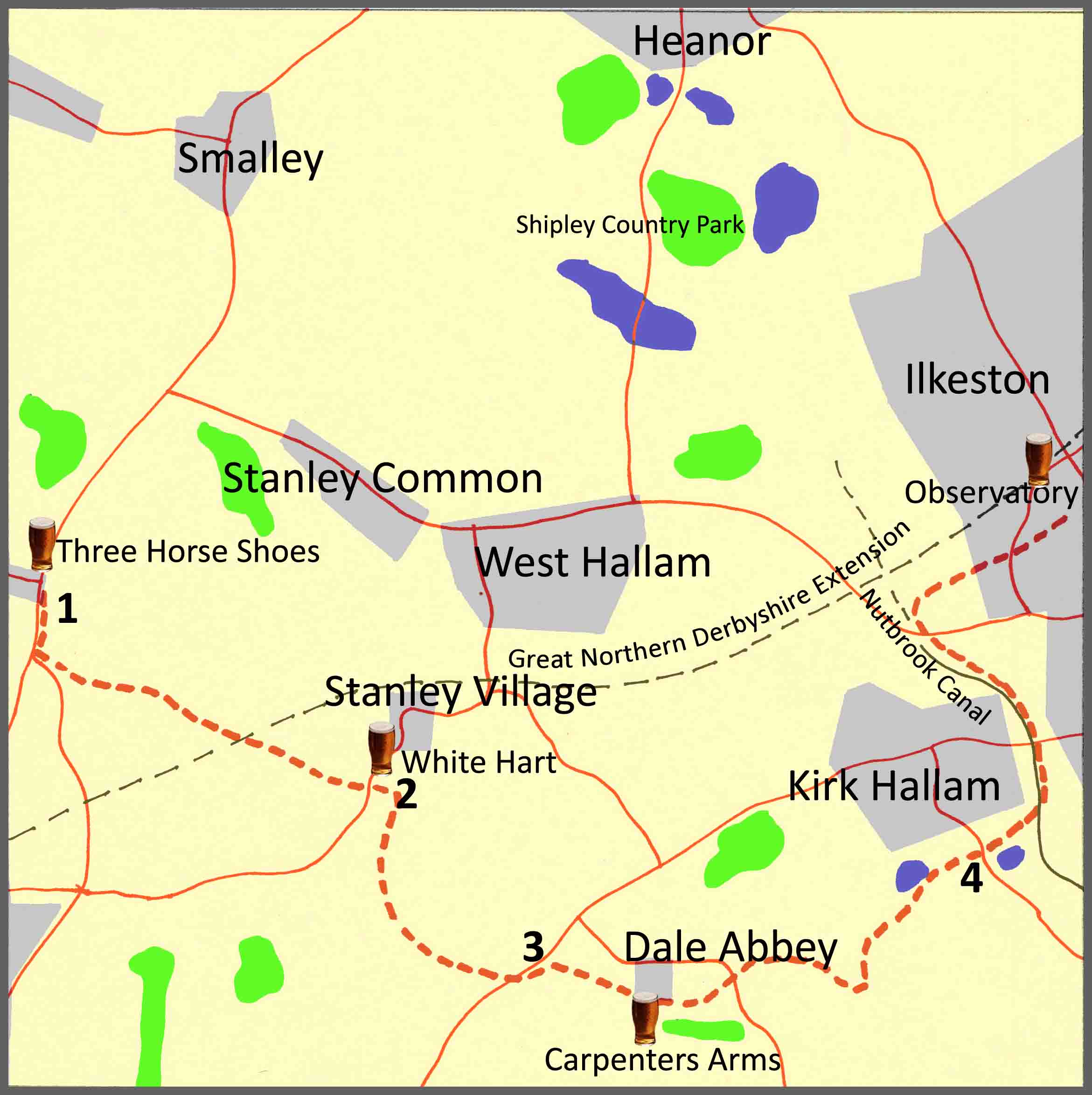
The walk described below starts at the Three Horse Shoes pub, Morley, continues into the villages of Stanley and Dale Abbey, before finishing in Ilkeston. However, the start and finish points are interchangeable, and you can easily get to them by a variety of local buses. If you wish, you can also reduce the length of the walk by catching a bus at a number of intermediate points.
The overall route covers nine miles of relatively easy walking with some moderate hills and some flat ground following sections of the defunct Nutbrook Canal and the route of a dismantled mineral railway line. There are four pubs featured en route, some fairly evenly spaced, serving good cask ales; so, at nine miles, it’s a comfortable four-pint walk allowing you to arrive home calorie neutral and none the worse for wear. The pubs are: the Three Horse Shoes at Morley; the White Hart at Stanley village; the Carpenters Arms at Dale Abbey; and J.D Wetherspoon’s Observatory at Ilkeston. Several other good pubs are available at Ilkeston.
As well as the good ale, there are also along the way a number of points of historical interest. These include: the route of the Great Northern Railway’s Derbyshire extension; the remains of a 12th century abbey and the Hermit’s Cave at Dale Abbey; the Nutbrook Canal and the dismantled mineral railway line which both once served collieries at West Hallam and Shipley.
Route Description
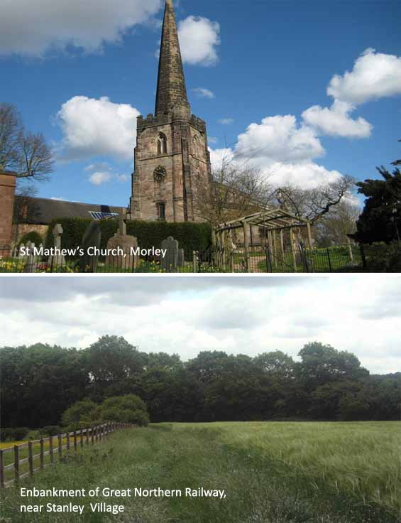
1. From the Three Horse Shoes pub, Morley, walk a quarter of a mile along the A608 in the direction of Derby and then turn left into Church Lane, bearing left again by the side of the church. Continue down Church Lane for just over half a mile and enter the field through the gate on your right. Follow the footpath along the field and go through a gate into the second field where the footpath will soon lead you to the disused railway which was once part of the Great Northern Railway’s Derbyshire Extension. Walk up and over the railway embankment and go through the gate into the field and walk along the footpath with the field hedge boundary to your immediate right. Enter the next field, over a stile, and follow the footpath that crosses the middle of the field, over a makeshift concrete bridge over a ditch. At the end of this field, there are three further fields to cross, and two footbridges, before reaching a kissing gate and an alleyway leading onto the main road, Derby Road, on the outskirts of the village of Stanley.
St Matthew’s Church, Morley is a Grade I listed building and features in Simon Jenkins’ book ‘England’s Thousand Best Churches’. The oldest part of the church dates back to the 13th century and is noted for its ancient stained glass windows which were removed from Dale Abbey at the Dissolution of the Monasteries in the 16th century. Church Lane follows part of the route of the Derbyshire Portway which is an ancient trackway, at least 3,000 years old, connecting the Bronze Age fort at Mam Tor to the North Sea via Nottingham. The Great Northern Railway’s Derbyshire Extension was completed in 1878 to counter the Midland Railway’s monopoly of the rail transport of coal from the surrounding Derbyshire and Nottinghamshire pits. This section, which ran from Nottingham to Derby, became defunct in the 1960s and is in the process of being reclaimed as a cycling and walking route.
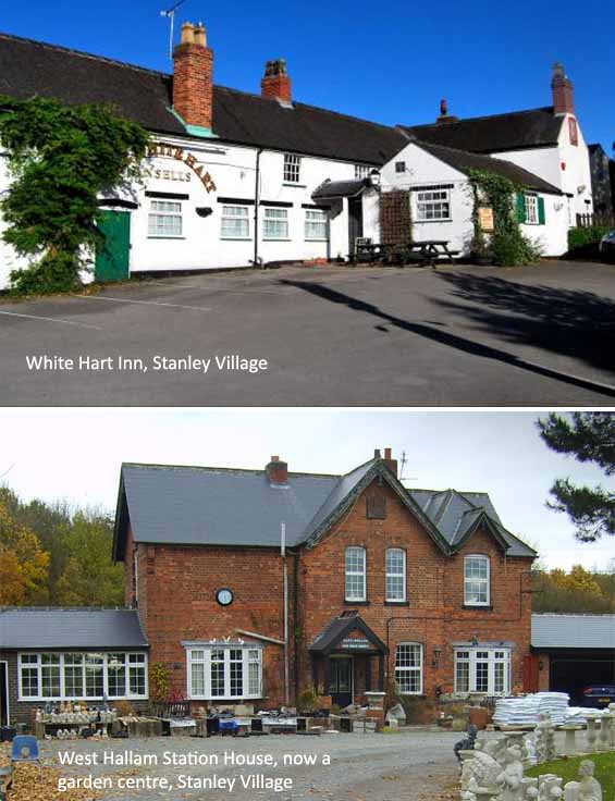
2. Having reached the outskirts of Stanley village, turn left onto Derby Road and walk just over two hundred yards towards the centre of the village where you will find the White Hart Inn on your left. Leaving the White Hart Inn, bear left and walk a hundred yards along Station Road and, just before you get to Hall Farm, take the footpath off to the right. Follow the footpath for three hundred yards, over the Stanley Brook, where you will reach Dale Lane Road. Cross over the road and go through the kissing gate and walk up the middle of field at top of which there is a stile leading to some farm buildings. Continue on the footpath, past the farm buildings, and carry on uphill over undulating ground until you will come to a stile at the top left-hand side of the field. Take the stile and follow the signs for the Midshires Way, along the fields and then on to the farm track to Hollies Farm Café.
Originally a Saxon settlement, by the seventeenth century Stanley had a reputation for Catholic sympathies at a time when Roman Catholics suffered oppression. Stanley Grange Farm, which once belonged to nearby Dale Abbey, housed a boys’ Catholic School and was raided twice, in 1637 and again by Parliamentary forces in 1642 during the English Civil War. Although essentially an agricultural area, Stanley did not escape the effects of the industrial revolution. On a map of 1793, very little can be seen around what is now Dale Road but the 1881 Ordnance Survey map shows a brickyard and clay pit, a colliery, rows of cottages and a pub. Stanley railway station was opened in 1876 by the Great Northern Railway but was renamed West Hallam to avoid confusion with another station in Yorkshire. Sunday passenger services finished in 1939, and it closed completely in 1964.
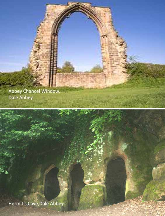
3. From the Hollies Farm Café, cross over the main Ilkeston to Spondon road, the A6096, and bear left, and approximately two hundred yards along take the stile to the right into the field. Follow the footpath through two fields and, ignoring two right hand turns off the main footpath, continue straight ahead along the main footpath that eventually leads down to the main road into Dale Abbey village. At the road bear left, uphill, to the Carpenters Arms. From the Carpenters Arms go back on yourself, into Dale Abbey Village, bearing left around the corner, past the remains of the abbey itself, and up to All Saints Church. Just before the church, follow the footpath off to the right, eventually bearing left to take you around the back of the church and up into Hermit’s Wood. Walk through the woodland past Hermit’s Cave up on your right and, through the gate, bear immediate left downhill across the field. At the end of the field, bear sharp right and take the stile into a field of rough ground leading up to a house on the left. Enter the big gateway, into a drive at the end of which is small gate leading onto the main road, Woodpecker Hill.
It is believed that the abbey, at Dale Abbey, was founded in the late 12th century and, in 1539, the Act of Dissolution brought an end to almost four centuries of monastic life there. Little remains of the original building except for a forty-foot-high arched chancel window. Some of the stonework of the building can be found in houses around the village. The last Abbot of Dale Abbey, John Bebe, died in 1540. The church of All Saints is one of the smallest in the country and dates back to the mid-12th century. It shares a roof with an adjoining farmhouse that may have been used as an infirmary for the Abbey. For some time before 1820 it was used as a pub called the Blue Bell, the bar being used as a vestry, with a door into the aisle of the church. In the woodland behind the church is Hermit’s Cave, hewn out of the sandstone cliff by a 12th-century Derby baker who lived there as a recluse.
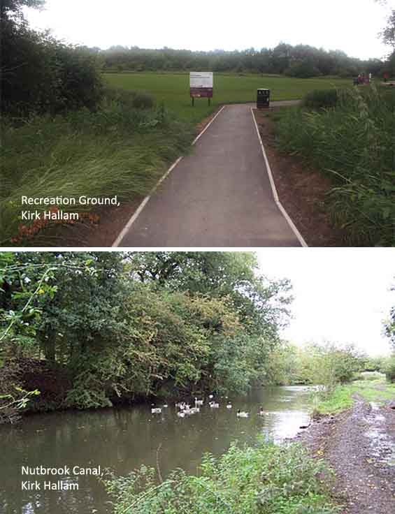
4. Bear left down Woodpecker Hill and at the bottom of the hill follow the lane off to the right. A hundred yards after the ford, bear right off the lane and continue straight ahead across the field at the end of which you will bear right onto a farm track. Walk to the top of the track and through the gates with cottages on your right. Just after the cottages, bear left across the field at the end of which the footpath turns sharp left along a hedgerow on your left. Follow the footpath across another field, eventually reaching woodland. Walk by the side of the woodland and the brook, Sowbrook, and then cross over a footbridge to bear right into the woodland. Continue through the woodland to exit onto the main road, Sowbrook Lane, on the outskirts of Kirk Hallam. Cross over Sowbrook Lane and, walking past Kirk Hallam Social Club, bear right to enter the recreation ground. Walk past the skatepark and exit the recreation ground to cross over what remains of the Nutbrook Canal. Bear immediately left to continue on the footpath running alongside the canal. At the sluice bear right and continue on the path until you reach the main road, Ladywood Road.
The Nutbrook Canal was completed in 1796 and was built to serve the collieries at Shipley and West Hallam. It ran for four and a half miles from Shipley, eventually joining the Erewash canal at Trowell. Benjamin Outram, who had completed the Cromford Canal and who was a partner of William Jessop in the Butterley Company, was appointed as engineer. When built, the canal had thirteen locks and was fed by Shipley Reservoir, which in turn was fed by the Nut Brook. It was initially profitable, but from 1846 faced competition from the railways and, more seriously, subsidence caused by the coal mines that it was built to serve. With the mines failing to pay tolls for goods carried on the canal, and in some cases refusing to accept responsibility for the subsidence, most of it was closed in 1895, although the final one and a half miles remained in use until 1949.
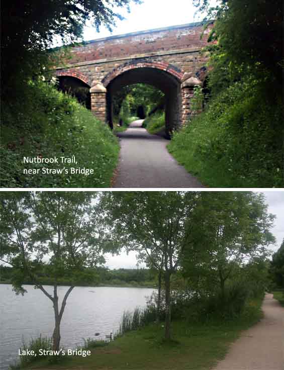
5. Cross Ladywood Road and bear right for twenty yards and take the steps off to the left, down to the dismantled railway line which is the Nutbrook Trail. Bear left along the Nutbrook Trail for three quarters of a mile until you reach Straw’s Bridge with the main West Hallam to Ilkeston main road crossing overhead. At Straw’s Bridge, bear right following the sign for Heanor and Shipley Country Park. Soon after the sign, you will bear right off the track to enter the municipal Pewit Golf Course. Carry on uphill, through the golf course, to Westend Drive. Continue to the end of Westend Drive, crossing over Oakwell Drive and Wharncliffe Road, walking to the end of Pimlico to enter Ilkeston market place. Here you will find several pubs and bus stops for Heanor, Derby, Long Eaton and Nottingham.
The Nutbrook Trail is a cycling and walking trail, part of National Cycle Route 67, that runs for ten miles from Long Eaton to Shipley Country Park, Heanor. The southern end, from Long Eaton to Stanton, follows the Erewash Canal, whilst the northern end, from Stanton to Heanor, largely follows the route of a dismantled railway line which had been built in the latter half of the 19th century to serve collieries at Shipley and Heanor. The mineral railway line was more efficient and more cost-effective than the Nutbrook Canal as a means of distributing coal from the local collieries and this helped to ensure the demise of the canal. From sections of the of the trail, built on the line of the dismantled mineral railway, you can see some evidence of the defunct Nutbrook Canal.