About this walk
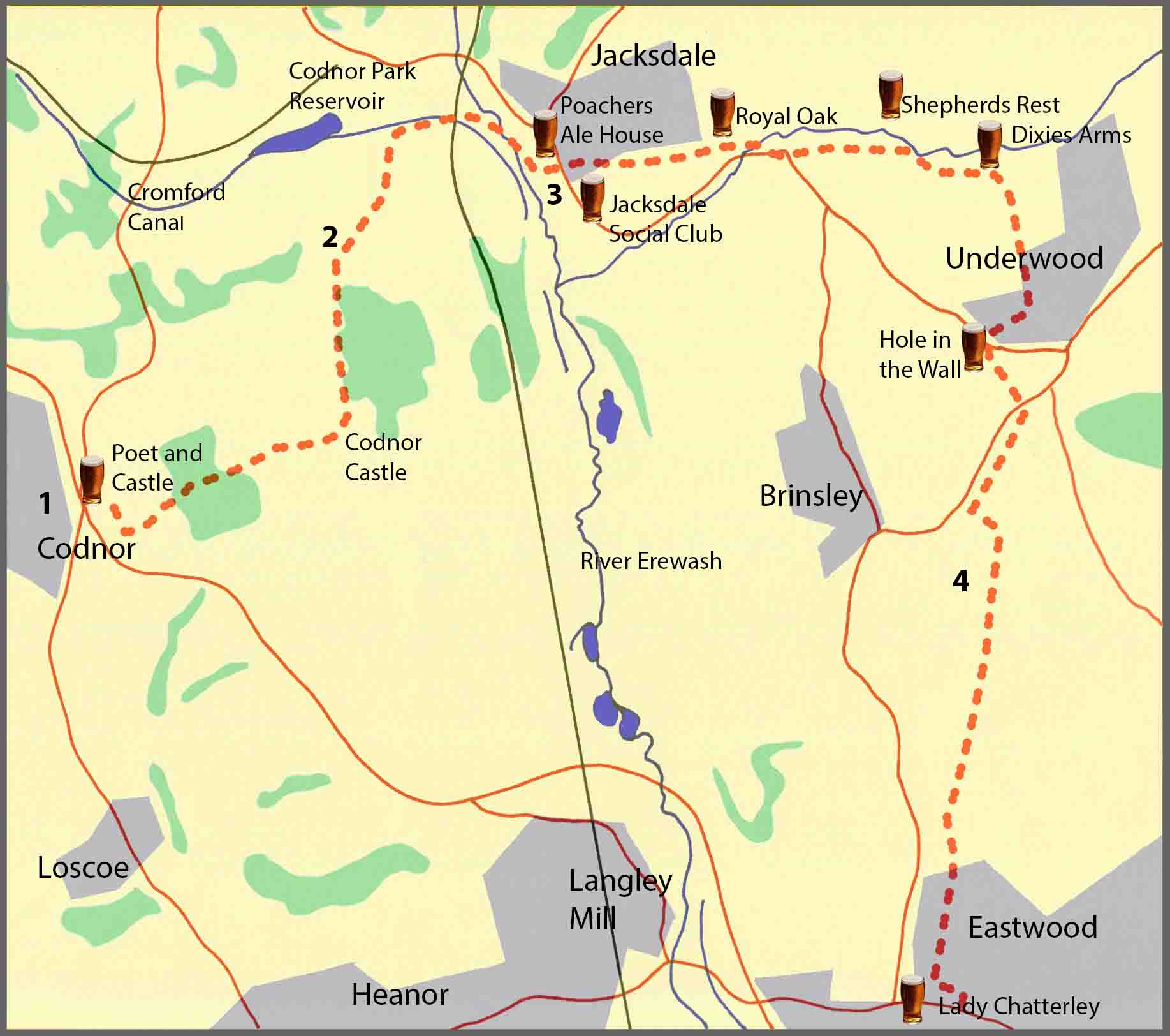
The walk described below starts at the Poet and Castle in Codnor and finishes in Eastwood. However, the start and finish points are interchangeable and you can easily get there by a variety of buses from Nottingham, Derby, Ripley and Heanor.
The overall route covers just over seven miles of relatively easy walking with some moderate hills and some flat ground where the walk follows a section of the old Cromford Canal. There are eight pubs en route, some evenly spaced, serving good cask ales. So, at just over seven miles it’s a comfortable three-pint walk, allowing you to arrive home calorie neutral and none the worse for wear. The pubs are; the Poet and Castle at Codnor, the Poachers Arms and the Jacksdale Social Club at Jacksdale; the Royal Oak at Westwood; the Shepherds Rest and the Dixies at Lower Bagthorpe; the Hole in the Wall at Underwood; and the Lady Chatterley at Eastwood.
As well as the good ale, there are also along the way a number of points of historical interest. These include: Codnor Castle, Jessop’s Monument, the Cromford Canal and the Codnor Park Reservoir, Codnor Park Ironworks, Jacksdale Wharf, the Brinsley Headstocks, and the birthplace of the writer D.H.Lawrence. Some background information about these points of interest, and relevant images, are featured in the route description below.
Route description
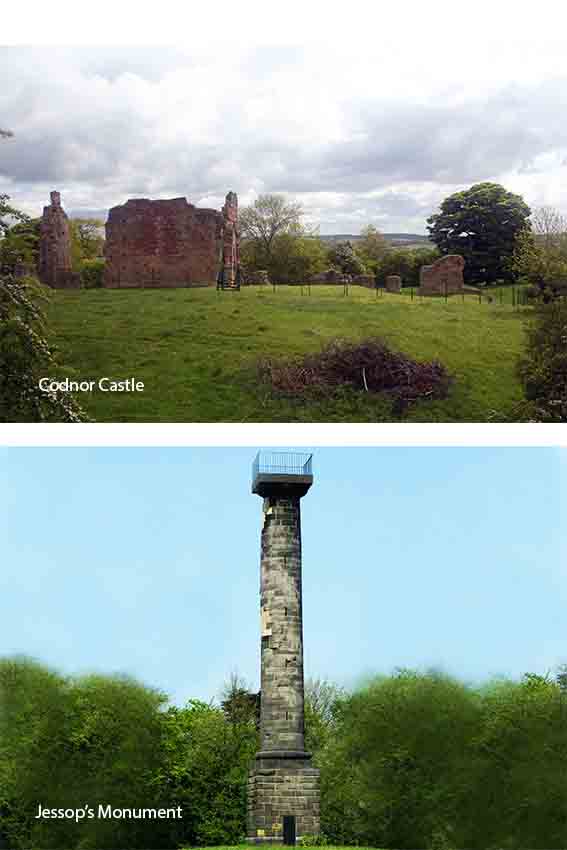
1. From the Poet and Castle, walk along the main road past the French Horn and bear left, past the Severn Almshouses, until you reach Goose Lane. Turn left here and continue on Goose Lane for about a quarter of a mile, passing the Codnor Sports Ground, until you reach a stile leading into a field on your right. Take the stile and walk down the field, following the hedge, until you come to the footpath that takes you left into Ormonde Fields Golf Course. Follow the footpath markers across the golf course, past the club house on your left, until you exit the course over a stile and into a field. Walk down the field, keeping the hedgerow to your left, until you reach Castle Lane. Turn left onto Castle Lane where the remains of Codnor Castle can be seen to the right, just beyond Castle Lodge Farm. Continue straight on for a further half a mile onto Monument Lane, going downhill past the water storage depot and Jessop’s Monument on your right.
Codnor Castle dates back to the 13th century and, for almost 300 years, the de Grays were Lord of the manor and estates. When ownership transferred to the Zouch family in the late 15th century, it is believed they began dismantling parts of the castle by selling stone for building, a practice that continued after their ownership ended in 1634. Eventually, in 1862, the castle and the estate were sold to the Butterley Company whose extensive mining activity further damaged the castle. The National Coal Board acquired the estate in 1978 and in 2008 UK Coal completed a programme of consolidation work designed to stop any further deterioration of the castle. Jessop’s Monument, known locally as the Codnor Park monument, was built in 1854 to commemorate William Jessop Jnr who had died two years earlier and who had been a central partner in the Butterley Company. (His father, also called William, was a famous canal engineer and one of the founding members of the company.) The monument is 70 feet high and is made of Ashler grit stone. It contains a spiral staircase leading to a viewing platform on top giving views of the Erewash valley and, in the past, of the Butterley Company’s ironworks at Ripley and Codnor Park. The monument and grounds were a popular attraction for Gala’s, and Sunday school outings.
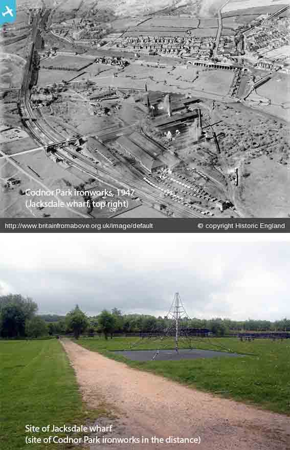
Ironville was built between 1834 and 1860, by the Butterley Company, as a model village providing workers’ homes, a church, a school and other public services including its own gas and water works, a Mechanics’ Institute containing ‘an artisans’ library’ and swimming baths. The Codnor Park reservoir was built to provide water for the Cromford Canal, also constructed by the Butterley Company. The company’s ironworks at Codnor Park, which at one time had four limekilns, two blast furnaces and a puddling forge, closed in 1965. The company’s remaining works at Ripley closed in 2009. The Jacksdale Wharf and Basin were created in 1822 to enable coal from the Portland Collieries at Kirkby in Ashfield to be loaded onto barges using the Cromford Canal. The coal was brought from Kirkby in Ashfield along the Portland Tramway, in horse-drawn wagons, though at two steep sections static steam engines were used to haul the wagons and to give the horses a break. Standing 30 feet above the eastern edge of the wharf, was the Great Northern Railway line which ran along a 21 arch viaduct. Further west, on the other side of the Cromford Canal and the ironworks, is the railway line built and run by the then Midland Railway company.
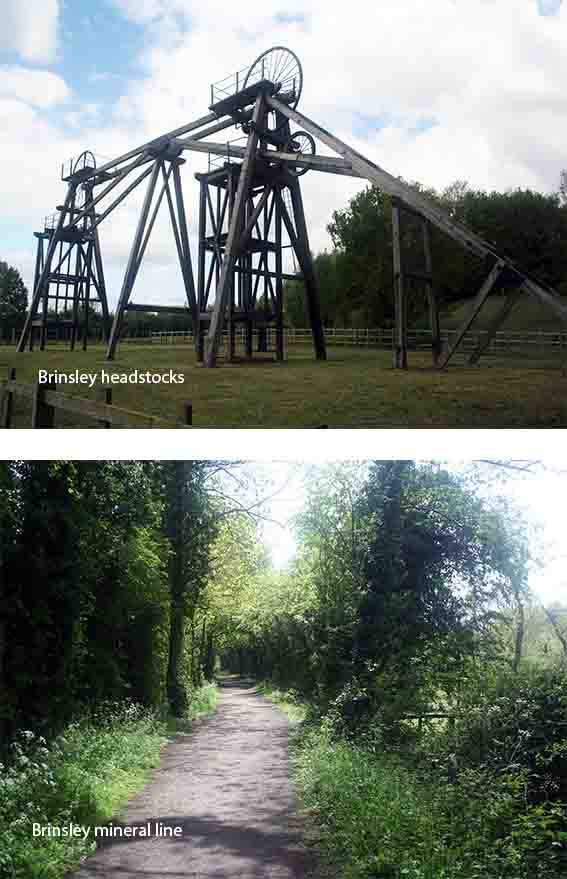
The tandem headstocks and the nearby disused mineral railway track are all that remain of the coal mining activities of the Barber, Walker & Company, who first leased, and then bought, much of the parish of Brinsley from the Duke of Newcastle. The Brinsley Colliery headstocks are believed to have been constructed in 1872 at a time when the Coal Mines Regulation Act of 1872 stated that no person should be employed in a mine unless there were at least two shafts in communication with each seam. Each cage, holding six men, was suspended from a steel cable that passed over the winding wheels to the drum of a steam winding engine. D.H.Lawrence’s father worked at the mine and the headstocks appear in the opening scenes of the 1960 film ‘Son’s and Lovers’ based on the writer’s semi-autobiographical novel. Production at Brinsley Colliery stopped in 1934 when its coal reserves were exhausted, though both shafts were kept until 1970 for access to neighbouring pits.
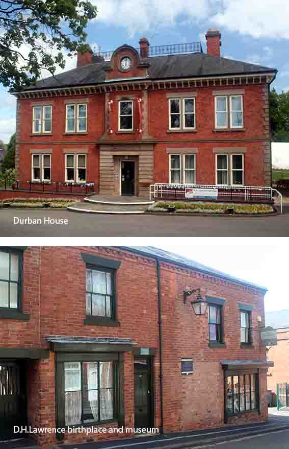
Eastwood Hall was built in the early 19th Century and was bought by the Walker family whose partnership with the Barber family appears to go back to 1787 and remained strong until 1947 and the nationalisation of the coal industry. The new National Coal Board then acquired Eastwood Hall, firstly as their Area Offices, and later as the Board’s National Offices where several crisis meetings took place during the National Miner’s Strike of 1984/1985. Durban House was built in 1876 as the offices of the coal owners Barber, Walker and Company, and it was from there that the young D.H Lawrence collected his father’s wages. Today, it houses the D.H.Lawrence Heritage Centre which promotes the literary legacy and physical locations of the writer’s life in this mining area. Lawrence was born at 8a Victoria Street, 1885, and next door, in the former shop, is the D.H. Lawrence Birthplace Museum. The Sun Inn’s claim to be the ‘birthplace of the Midland Railway’, goes back a meeting of Nottinghamshire mine owners in 1832, at the Sun Inn, when a scheme was formally approved to extend the Mansfield and Pinxton Railway to Leicester. This extension was known as the Midland Counties Railway and it, together with other extensions, formed the basis of what was later known as the Midland Railway.