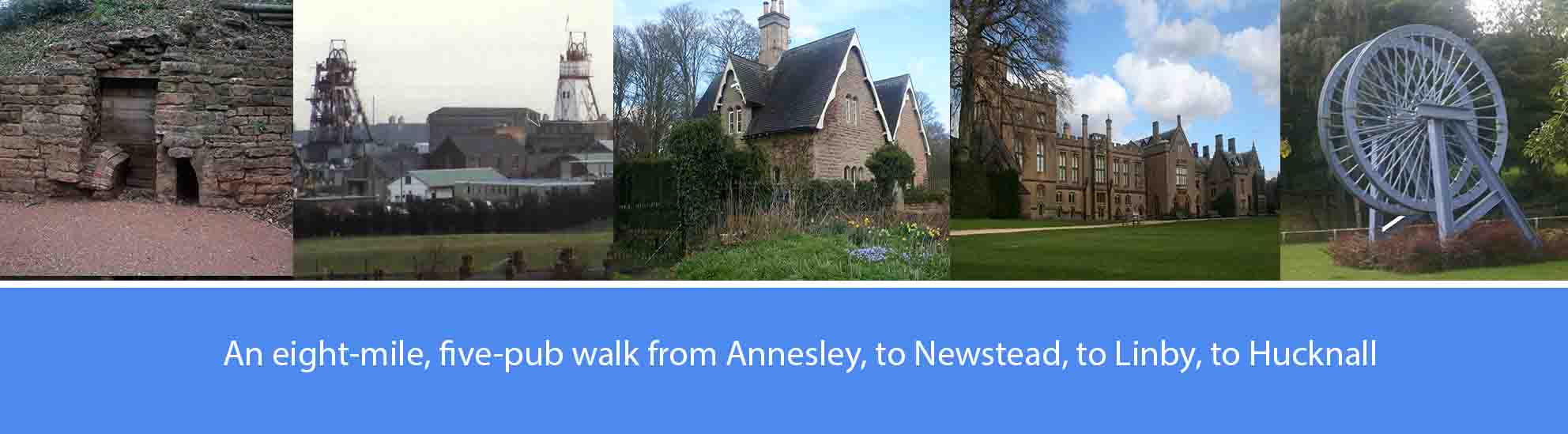
About this walk
The walk described below starts from the Badger Box in Annesley, through the Newstead and Annesley Country Park, through the Newstead Abbey estate, and through the villages of Papplewick and Linby before finishing in Hucknall. However, the start and finish points are interchangeable, and can be reached by regular buses from Nottingham, or Mansfield and several other local towns.
The overall route covers just over eight miles, most of it off-road, over old colliery workings now restored as wildlife areas, and through established parkland. There are five pubs featured en-route, serving good cask ales; so, at eight miles, it’s a comfortable three or four-pint walk, allowing you to arrive home calorie neutral and none the worse for wear. The pubs are: the Badger Box at Annesley; the Pit at Newstead Village; the Griffin’s Head Inn at Papplewick; the Horse and Groom at Linby; and the Station Hotel at Hucknall. Several other good pubs are available at Hucknall. Bottled ale is occasionally available at the Newstead Abbey café.
As well as the good ale, there are also along the way a number of points of historical interest. These include: the sites of the old collieries at Annesley, Newstead and Linby; Newstead Abbey and Newstead Estate; the restored industrial archaeological sites of the cotton mills along the River Leen; and the old Linby Colliery.
The route description
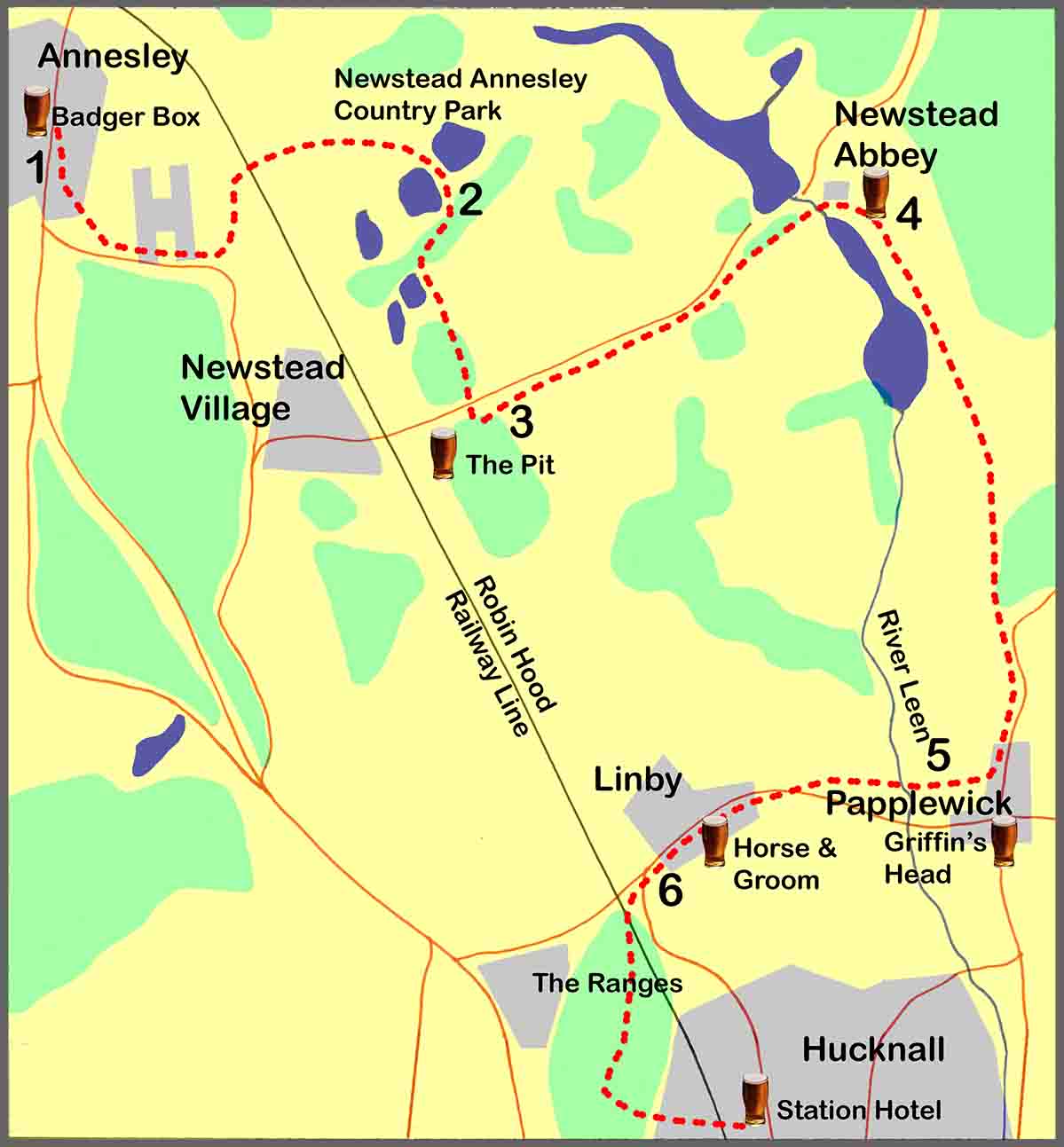
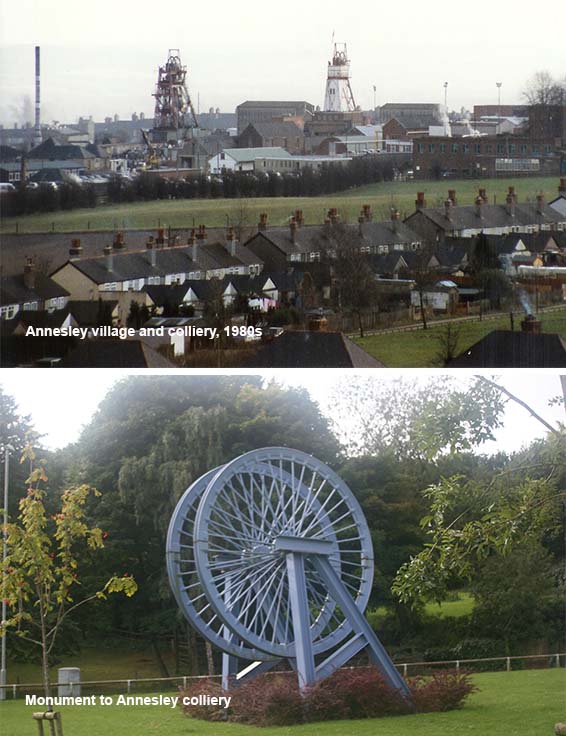
1. On the opposite side of the road from the Badger Box pub, walk out of Annesley for about 300 yards and bear left into Annesley Cutting towards Annesley Church. In front of the church, take the footpath off to the right and walk through the woods until you re-join Annesley Cutting. Bear left and, after passing the terraced rows of Byron Road and Moseley Road, turn into the new housing estate, passing the colliery headstocks monument on your right. After approximately two hundred yards further down into the new estate, bear left onto a rough track which follows the line of one of the old colliery railways. After two hundred yards, the track will curve to the right to take you under a railway bridge carrying the Robin Hood railway line. Enter the Newstead and Annesley Country Park straight ahead of you and follow the track all the way to the top of the hill where you will reach the first of the old colliery lagoons.
Newstead and Annesley Country Park has been created from the spoil heaps, lagoons, and rail and coal stocking yards from the collieries of Newstead and Annesley and nearby Linby. Deep mining began at Newstead in 1874 with the sinking of two 13ft diameter shafts by the Newstead Colliery company. After nationalisation in 1947, Newstead colliery was at the forefront of developments in mechanised extraction and was one of the first pits in Britain to turn a million tons of coal in one year. After severe geological problems, Newstead closed in 1987. Annesley colliery was one of the earliest deep coal mines to operate in the area with shafts sunk in 1865 and, at the time of its closure in 2000, it was the oldest working coal mine in Britain.
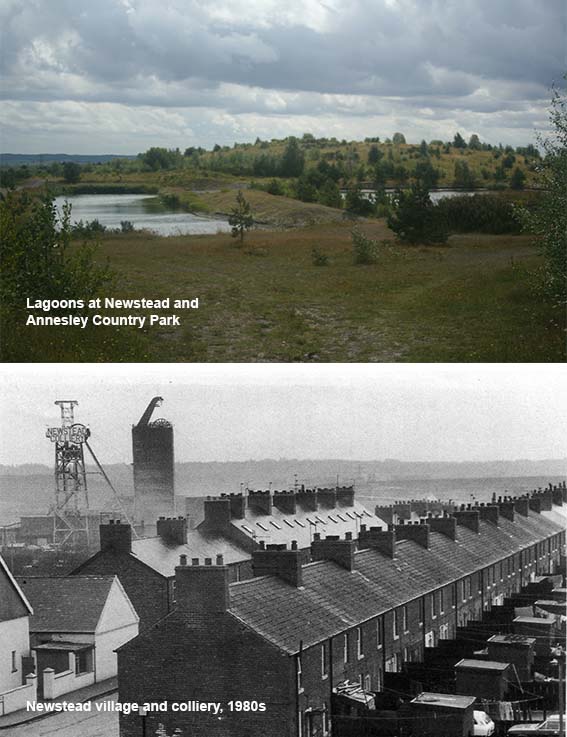
2. Having reached the top of the hill, go straight ahead following the middle track that takes you between two of the old colliery lagoons. Continue downhill towards the fishing ponds and the visitor centre. Just before the visitor centre, bear left off the main track and take the footpath to walk alongside the fishing ponds which will be on your right. After the fishing ponds, follow the footpath passing, on your right, the recreation ground and, beyond that, Newstead village. After approximately four hundred yards you will pass over a bridge to join the Linby Trail. Immediately after the bridge, leave the Linby Trail and turn left onto a footpath. Follow the footpath for about a hundred yards and, where it meets Station Avenue, bear right through the entrance to Newstead Abbey grounds.
The various lakes of the Newstead and Annesley Country Park are an adaptation of lagoons originally constructed by the coal authority to deal with polluted water pumped out of the Erewash Valley coal mines. The water from the mines was polluted with salts and an iron ore solution called ochre and, to deal with this pollution, a series of some six interconnecting lagoons were constructed that ultimately fed into a 17 kilometre pipeline that took the water from Newstead to enter the River Trent, just north of West Bridgford. As the water flowed through interconnecting channels, from lagoon to lagoon, it became aerated and the oxidation process caused the ochre solution to thicken so that the ochre would sink to the bottom of the lower lagoons in the form of thick silt, thereby lowering the level of this pollutant in the water. The salt was dealt with by simply being diluted to an acceptable level in the waters of the River Trent.
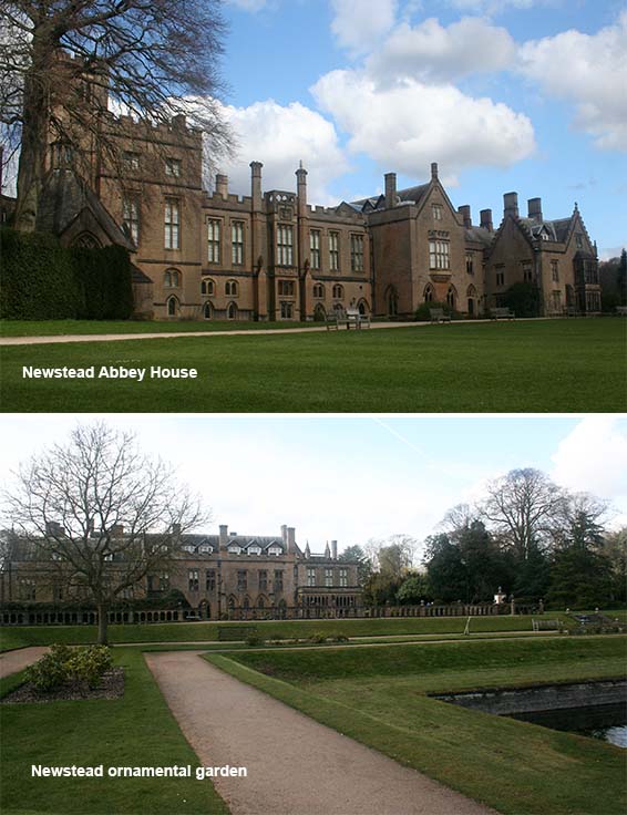
3. From here, the quickest route to Newstead Abbey is to continue walking along Station Avenue for just over a mile to reach directly the Abbey ruins and the house. However, the more scenic route is to walk along Station Avenue for about three quarters of a mile and, as the road curves to the left, to take a footpath off to the right. Carry on this footpath, which initially runs parallel to the road, and then bear right through a gate and walk diagonally across an open field at the back of Newstead Abbey garden lake. Having crossed the field, cross the wooden footbridge over the River Leen and bear left to walk uphill towards a small enclosed brick building which used to be the Newstead Abbey sewage works. Carry on past the old sewage works to enter the rear of the Abbey gardens and grounds.
The Abbey was founded in the late 12th century as a priory for an Augustian religious community. One of the duties of a priory was to provide hospitality to travellers lying, as it did, so conveniently close to the royal hunting grounds of Sherwood. With the dissolution of the monasteries under the reign of Henry VIII, the estate was transferred to Sir John Byron, Lieutenant of Sherwood, and it remained with the family until sold by the poet, Lord Byron, in 1818. The Abbey, now owned and maintained by Nottinghamshire County Council, contains an intriguing collection of Byron memorabilia, including his pistols and boxing gloves. In the walled garden there is an eccentric memorial to Byron’s dog, Boatswain. Much of the original priory has survived, including the cloisters in which the monks studied, the refectory where they ate, and the “Stew pond” in the grounds, which provided the brothers with fish, and the octagonal kitchen where it was cooked.
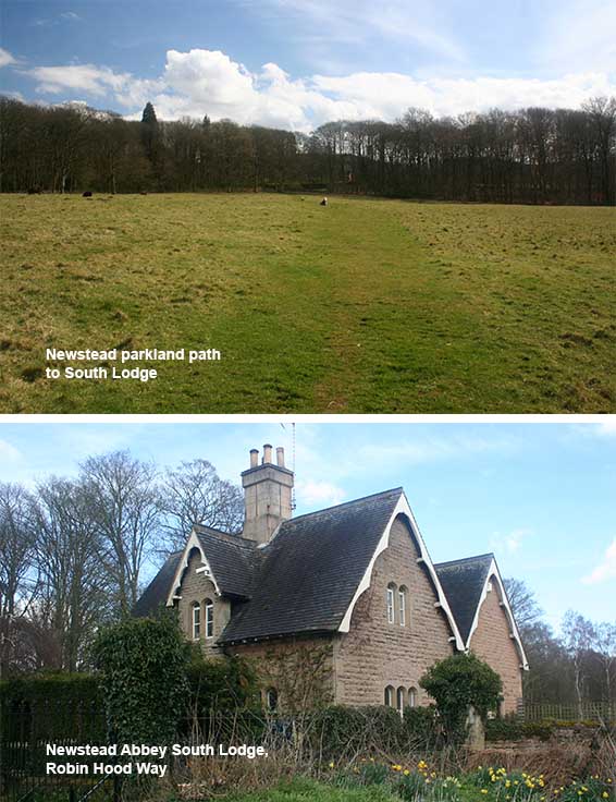
4. To continue the walk from the Abbey gardens and grounds, retrace your steps back to the old sewage works where, over to the left, you pass through a gate into open park land. Bear right across the park land, aiming for a house in the distance which was once the Newstead Abbey’s South Lodge. At the lodge house, you bear right onto the tarmac track known as Robin Hood Way which was once part of the route of the main road from Linby to Mansfield. Continue along Robin Hood Way for approximately three quarters of a mile until you reach the junction with the main road to Papplewick and Linby. At the junction, bear right to walk along the road into Papplewick village. Just as you enter Papplewick, take a right turn into a narrow lane that leads to St James’ Church, Papplewick. Two hundred yards down the lane, bear left onto a track, past the church over on your right, until you come to the River Leen where the track forks to the right and left.
The Robin Hood Way is a long distance footpath linking Creswell, Clumber and Thoresby in the north of Nottinghamshire, to Nottingham Castle in the south. The section of the Robin Hood Way that runs through the Newstead Estate, follows the route of the ancient road from Nottingham to Mansfield which was closed in 1760 by an Act of Parliament, one argument for its closure being that many travellers lost their way on it. In the times of Robin Hood, the road would have been all in Sherwood Forest and to travel between the two places would have been hazardous. A turnpike road was created from Larch Farm, to replace the old road.
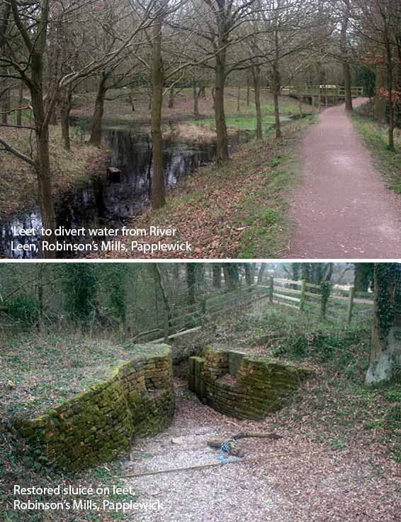
5. At the River Leen, take the right-hand fork of the footpath and, after walking along the edge of a large open field, you will come to the main road into Linby where you will turn right to find the Horse and Groom further along. (Alternatively, the left-hand fork leads to an interesting diversion exploring the industrial archaeological sites of the area’s 18th century cotton mills. The left-hand fork leads to a footbridge over the River Leen. The track then bears left through the woodland to follow the meandering river. After a few hundred yards, up a flight of steps, the track exits the woodland onto the main road which, bearing left, leads into the centre of Papplewick and the Griffin’s Head Inn. Cross over the road and bear left along the pavement for about a hundred yards until you reach a footpath on your right. The footpath will take you through woodland, past several more features associated with the cotton mills.)
Water powered mills have existed along the River Leen in the parishes of Papplewick and Linby since at least 1232, but it wasn’t until the 18th century, largely as result of the Robinson family, that the power of the river Leen was developed on an industrial scale for the processing of cotton. The Robinsons not only built cotton mills, and converted existing corn mills, but they also spent a considerably large amount of money in improving the power of the water supply, including the creation of Papplewick Dam, Moor Pond and a network of connecting channels, or “leets”, that fed water all the way south to Bestwood. The Robinsons employed around 800 people along the Leen Valley, including apprentice boys from the St. Marylebone Workhouse in London. There is little evidence to support the legend that the apprentices were brutally treated and that hundreds are buried in unmarked graves in Papplewick and Linby churchyards.
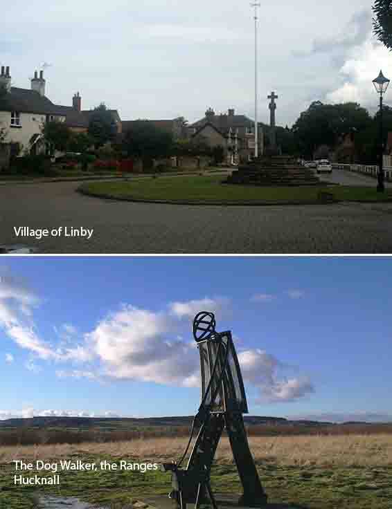
6. From the Horse and Groom, bear right and walk out of Linby until you come to the roundabout. Bear right at the roundabout and cross over the road and walk towards the railway level crossing. Immediately after the crossing, turn left onto the track to enter the Ranges, a nature reserve formed from land reclaimed from the old Linby colliery and slag heap. A hundred yards along the track turn right to follow the track to the top of the old slag heap, passing the Dog Walker statue, and then walk down the other side to reach to reach Linby Walk. Follow Linby Walk until you eventually reach Linby Road where you bear right to walk into Hucknall town centre, the Robin Hood line railway station and the Station Hotel.
Coal mining at Linby Colliery began in 1873 and finished in 1988. In the 1960’s the colliery was one of the most productive in Europe but, towards the late 1970’s, the colliery’s fortunes started to decline as coal seams became exhausted. The site was subsequently purchased by the County Council from British Coal in 1992. The former tip site has been restored to public open space comprising a mix of woodland, grassland and wet areas known as The Ranges. Restoration was completed in 1997 and now provides some 30 hectares of recreational resource for the local community. The area is crossed by a number of surfaced paths which link into the wider public rights of way network and the local estate roads of North Hucknall. In 2007, the statue, The Dog Walker, was erected at the former pit tip’s summit.