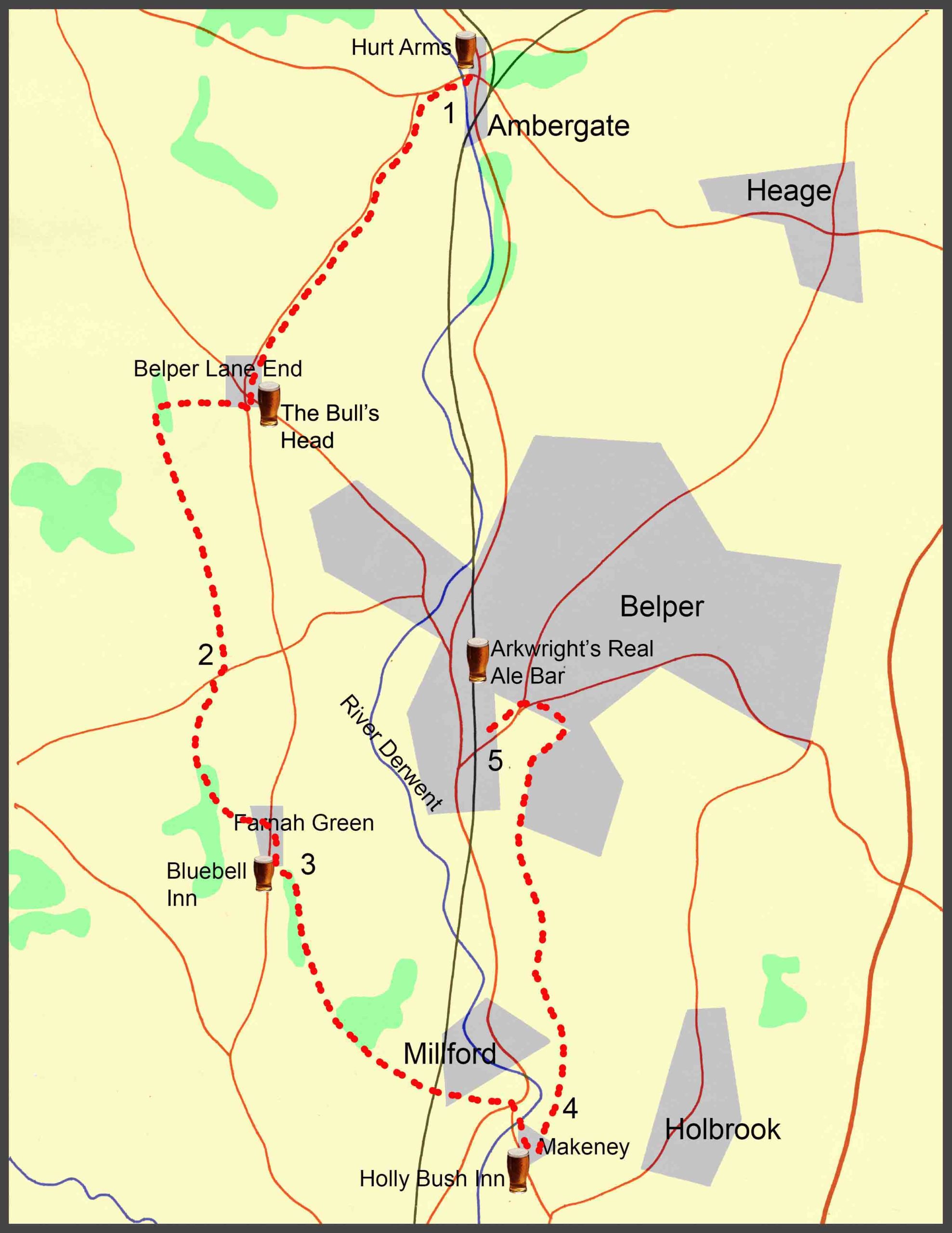
About this walk
The walk described below starts from Ambergate and passes through Belper Lane End, Farnah Green, Milford and Makeney, before finishing in Belper. However, the start and finish points are interchangeable, with good bus services from both Derby and Nottingham, and a train service from Derby.
The overall route covers just nine miles following undulating footpaths and bridle ways. There are five pubs featured en-route, evenly spaced, serving good cask ales; so, at nine miles, it’s a comfortable four-pint walk, allowing you to arrive home calorie neutral and none the worse for wear. The pubs are: The Hurt Arms at Ambergate, the Bull’s Head at Belper Lane End; the Blue Bell Inn at Farnah Green; the Holly Bush Inn at Makeney; and Arkwright’s Real Ale Bar at Belper. Several other good pubs are available in Belper.
As well as the good ale, there are also along the way a number of points of historical interest covering many centuries. These include: Shining Cliff Wood and the Grith Pioneers, the Anglo-Saxon Portway and Stephenson’s Tower at North Lane, the mills at Milford, the 17th century Hollybush Inn at Makeney, and the nail-making and textile industries of Belper.
The route description
- On the main road from the Hurt Arms, walk past the cricket ground and bear right at the Church into Holly Lane. Walk down the lane, over Happenny Bridge, crossing the River Derwent at the point where it is joined by the River Amber. Over the bridge, with Shining Cliff Wood on your right, bear left and walk steeply uphill on the road until you reach a junction with Whitewells Lane off to your left. Turn into the lane and continue down it for approximately a mile until you reach the Bull’s Head at Belper Lane End. Walking past the pub, and the house next to it, turn right off the road and into a short lane that leads to a footpath. Take the footpath and climb uphill, going over a stile at the top of the field to enter a wooded area. Carry on walking uphill through the woods and over another stile that soon leads onto a track which is the Midshires Way. Turn left onto the Midshires Way, and carry straight on for about half a mile until the track leads to a rocky path that goes steeply downhill and eventually joins Holly House Lane.
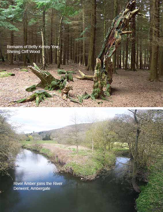
Shining Cliff Wood is ancient woodland which was part of the royal hunting forest of Duffield Frith and is now a designated site of special scientific interest. The woodland includes many oak, sweet chestnut and larch trees, and it supports a diverse bird community including warblers, flycatchers and bramblings. There is a circular waymarked trail which passes by the remains of the Betty Kenny Yew Tree, said to be the source of the lullaby ‘Rock-a-by Baby’. In the 1930s, the wood was the site of a work camp where local unemployed men were encouraged to create a self-sufficient a land-based community. The wood is owned and managed by the Grith Pioneers, a trust which can trace its origins back to the Grith Fyrd, or ‘Peace Army’, a radical alternative educational movement launched in 1931.
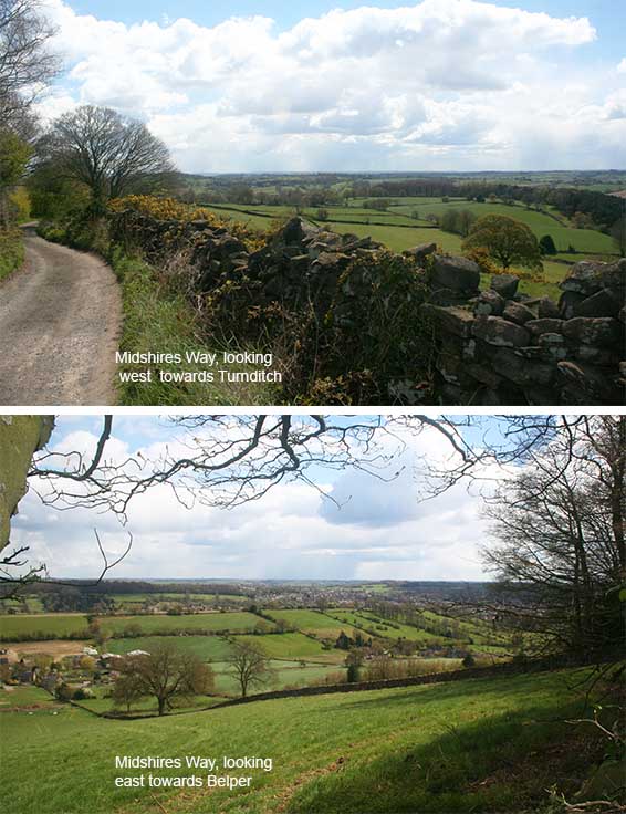
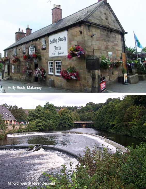
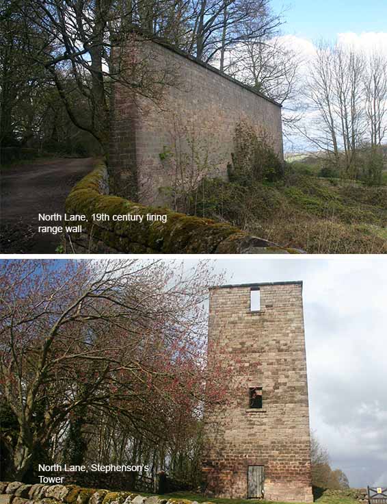
3. Bear right onto the main Farnah Green road and, crossing over to the other side, after approximately a hundred yards turn left into a narrow lane. (The Blue Bell Inn is approximately another hundred yards further along the main road on the right hand side.) Walking past Chevin House, take the bridleway which soon bears sharp right and continues uphill onto the ridge, North Lane, with the Derwent valley below. Continue along North Lane, passing a huge stone wall on your left and Chevin golf course on your right, eventually reaching Stephenson’s Tower on your left and, on your right, one of the ventilation shafts for the railway tunnel that passes beneath the track. Walk past the Tower and ventilation shaft, where the track soon joins Sunny Hill leading steeply downhill into Millford. At the bottom of the hill, cross over the road and, past a row of mill cottages, take the alley to the main A6 linking Derby with Belper and Matlock through the Derwent Valley.
North Lane is part of an ancient trackway believed to have been used by the Romans to carry lead from the Wirksworth area to Duffield and which later became part of the Anglo-Saxon Portway running across Derbyshire. The tall stone wall to the side of North Lane, overlooking Belper, is part of the firing range built in the nineteenth century for the local militia to use for target practice. Stephenson’s Tower stands directly over the Chevin railway tunnel, and was built about 1839 by the North Midland Railway Co., with Chief Engineers, George and Robert Stephenson. Now a listed building, it has been suggested that it may have been used as a siting tower or theodolite during the surveying of the line. It is also suggested that it was used to signal to locomotive drivers that the tunnel, originally single-tracked, was clear to enter and later, after a second track had been laid, to prevent two trains being in the tunnel at once whilst open carriages were still in use.
5. Bear right at the main road and, crossing over the road, take the next left turn into Canada Street. At the bottom of Canada Street, turn right into Melbourne Close and, at the top of the Close, bear left where, after a few yards, the road joins a footpath with an entrance, off to the right, into Belper Parks. Take this entrance and walk all the way through Belper Parks for about half a mile. As you exit the Parks, turn left onto Mill Lane and walk down the hill until you will bear right into Park Side. Walk up the hill, through the Butts until it joins the main Nottingham Road where you will see to your right a row of some of the cottages that were once home to the old nail-making cottage industry of Belper. Across from the cottages, bear left, down High Pavement, through the old Market Square and down into King Street in the centre of Belper.
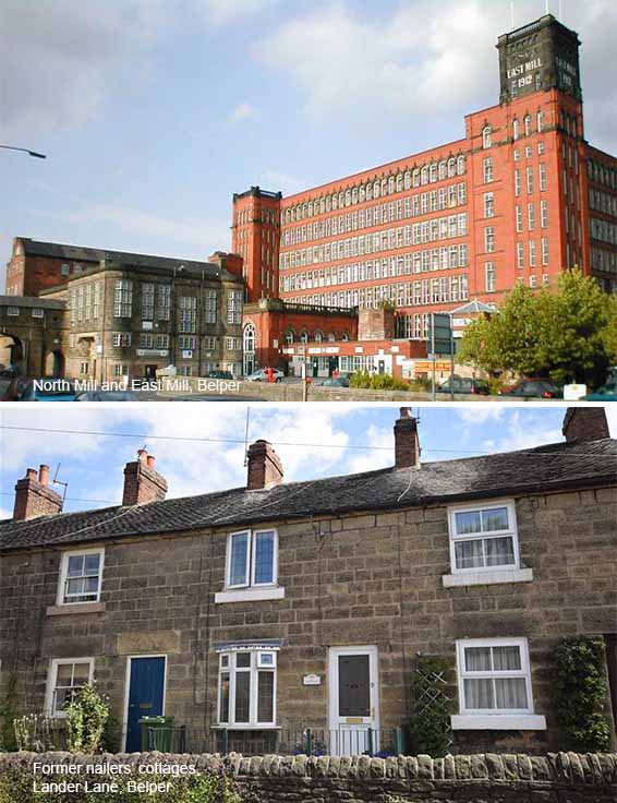
Belper Parks is a remnant of the Belper Deer Park which, like Shining Cliff Wood, was once part of the royal hunting forest of the Duffield Frith. Belper had been a centre for the nail-making industry since Medieval times and, in the first half of the 19th century, up to two million nails a week were being made in Belper. At this time, nail-making was essentially a home industry, and the whole family would help out in the workshop, typically at the back of each nailer’s cottage. However, as the factory system became established, the Belper nailers’ methods seemed outdated, and other nail-making regions which embraced the new methods of production, like Birmingham, soon eclipsed Belper. During the 19th century, factory-based textiles production took over as the main source of employment in Belper. Jedediah Strutt built his first mill here in 1776 and the North Mill, which stands overlooking the Derwent, was built in 1804 by Jedidiah’s son, William Strutt. The much larger East Mill was built in 1912.
2. Continue down Holly House Lane and then onto Longwalls Lane which then leads to the main road at Blackbrook. Turn right onto the main road, cross over to the other side, and walk for about a hundred yards to just before the bus stop where you will bear left onto the bridleway which is a continuation of the Midshires Way. At the ford, cross over the stream via the footbridge. Carry on the track for about half a mile, past the farm on the left, and take the footpath off to the left marked as the Midshires Way. The path soon leads through a gate, across an open field, and on to another gate leading into woodland. Continue on the woodland path for about half a mile until you come to a stone stile to your left. Climb over the stile and follow the path along the edge of a field at the end of which there are two stiles either side of a track. After the second of these two stiles, the Midshires Way continues up what appears to be a private drive taking you up to the main road at Farnah Green.
The Midshires Way is a long-distance footpath and bridleway that runs for 230 miles from the Chiltern Hills in Buckinghamshire, through the Midlands counties of Northamptonshire, Leicestershire, Nottinghamshire and Derbyshire, to Stockport, Greater Manchester. It also links several other long-distance walking routes or trackways including the Ridgeway and the Trans Pennine Trail. The route was opened in 1994 as a collaboration between numerous Local Authorities and user groups. It is intended as a multi-user trail but there are places where the recommended route for walkers differs from the route for horse riders and cyclists. The Derbyshire section starts at Sawley near Long Eaton running to Duffield then linking with the High Peak Trail close to Wirksworth. The route passes through the Peak National Park and on to Buxton. The trail then follows the Goyt Valley towards Stockport.
4. At the A6, bear left to walk over the bridge that crosses the River Derwent. Cross over the road at the King William, then bear right and walk along Makeney Road for approximately a quarter of a mile until, on your left, you reach Holly Bush Lane at the top of which is the Holly Bush Inn. Opposite the Holly Bush Inn car park, walk up Dark Lane for about a hundred yards and bear left over the stile and continue uphill hill through the field. At the top, bear right through a stone stile and follow the path along the edge of the field to another stile that takes you uphill through the middle of the field. At the top of the hill, take the stile where the path runs along the edge of woodland on your right, finally coming to a minor road which you cross, over the stone steps. Continue on the footpath along the edge of the fields until you come to a fork in the path where you will bear right, across the field, until you reach a gate leading to a farm track. Go through the gate and bear left along track for about half a mile to reach the main road on the outskirts of Belper.
Until the end of the 18th century, Milford was little more than a few houses not far from where the Roman trackway, and the Anglo-Saxon Portway, descended into the village by what is now Sunny Hill, to ford the river. In 1778, Jedediah Strutt built cotton spinning mills after the system developed by Richard Arkwright at his mills at Cromford. Part of the Milford mill still exists as well as much of the workers’ housing. One of Strutt’s apprentices at Milford was Samuel Slater who, carrying Arkwright’s system in his head, famously absconded to America where he settled in Pawtucket, Rhode Island, and replicated Arkwright’s success. The Holly Bush Inn at Makeney, believed to have been built in the late 17th century, is a Grade II listed building and is on the Campaign for Real Ale’s National Inventory of Historic Pub Interiors.