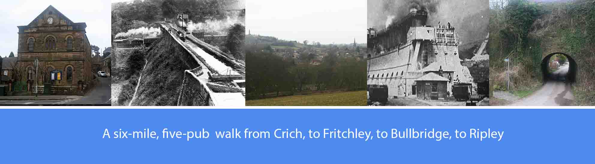
About this walk
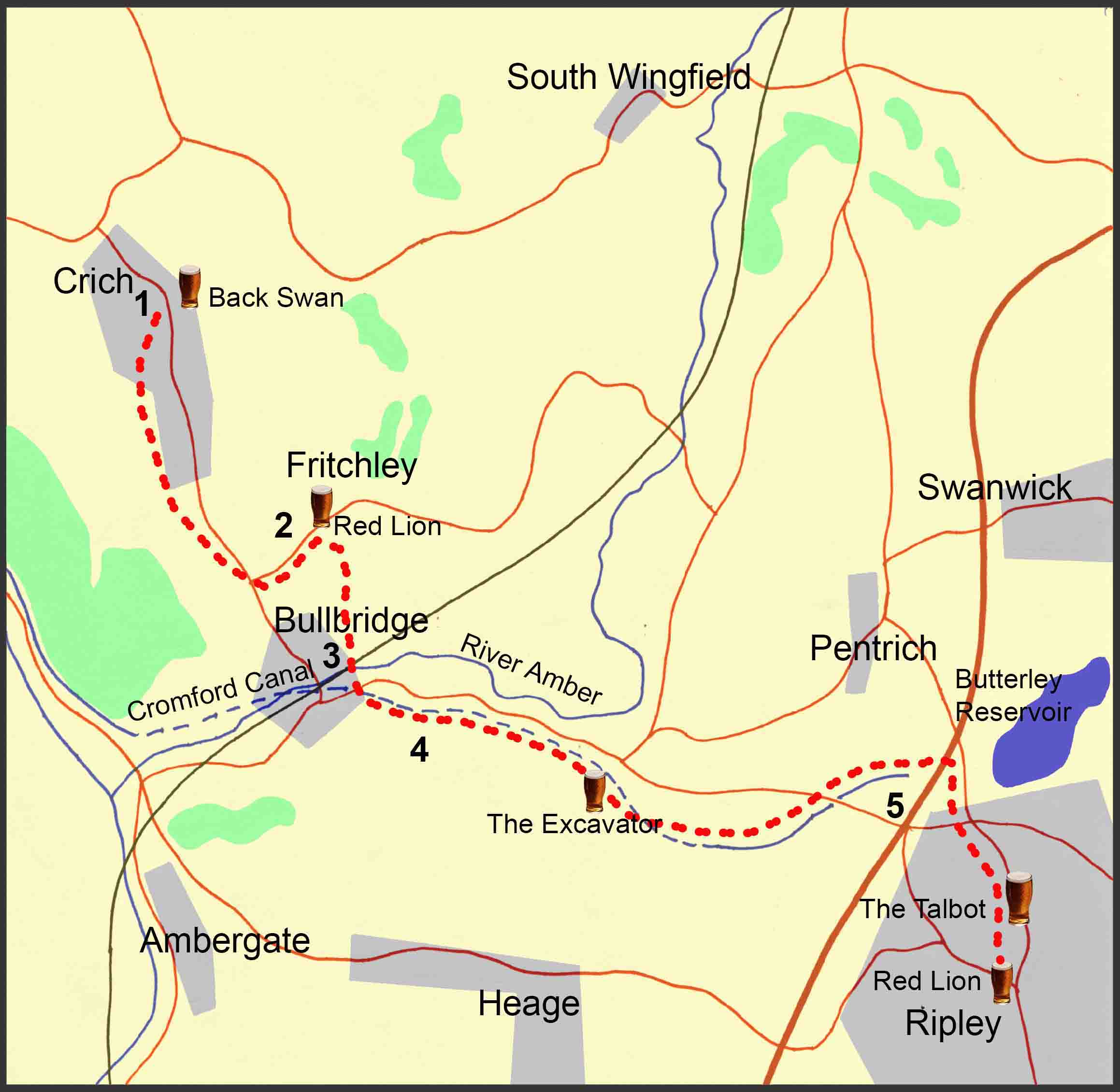
The walk described below starts from the Market Place in Crich, and then on to Fritchley, Bullbridge, and ends in Ripley. However, the start and finish points are interchangeable, with good bus services from Nottingham and Derby to Ripley, and from Ripley or Alfreton to Crich.
The overall route covers just over six miles, mostly off-road. Some sections follow the routes of early railway, or gangroad systems and other sections follow the route of the Cromford Canal on its way to Ripley. There are five pubs featured en-route, serving good cask ales; so, at just over six miles, it’s a comfortable three-pint walk, allowing you to arrive home calorie neutral and none the worse for wear. The pubs are: The Black Swan at Crich; The Red Lion at Fritchley; the Excavator at Buckland Hollow; J D Wetherspoon’s Red Lion and the Talbot at Ripley. Several other good pubs are available at Ripley.
As well as the good ale, there are also along the way a number of points of historical interest. These include: the limestone quarries in Crich; the now defunct early railway, or gangroad, systems that once connected the Crich limestone quarries with the Cromford canal and, later, with the mainline rail system; the old lime kilns at Bullbridge; and the Cromford canal that once connected Cromford with the Langley Mill canal basin.
The route description
1. Cross the market place in Crich with the Babtist Church in front of you. To the right of the church, walk up Sandy Lane for about three hundred yards, passing the old Crich Reading Room on your left, until you reach the two circular stone enclosures, also on your left, that commemorate the Golden and Diamond Jubilees of Queen Victoria. After the second of the two enclosures, take the footpath off to the left and walk for about half a mile across the fields until you reach a flight of steps leading down to Chadwick Nick Lane. At the bottom of the steps, bear left and walk down the lane for about half a mile until you reach the junction with Top Hagg Lane. Turn right into Top Hagg Lane and, after approximately a hundred yards, take the footpath that goes off to the left between two houses and that leads steeply downhill to Crich Road.
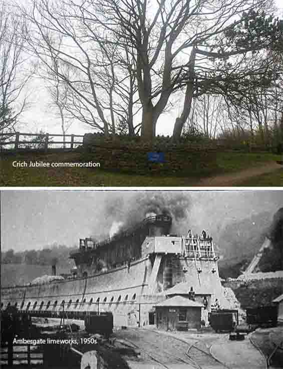
The first of the two circular stone enclosures was built in1887 to commemorate Queen Victoria’s Golden Jubilee, with the second built in 1897 to commemorate her Diamond Jubilee. In each enclosure a tree was planted.
In the ground underneath the two stone enclosures, a tunnel ran under Sandy Lane to enable a railway to carry limestone from Cliff Quarry, now the site of the Crich Tramway Museum, to a major limeworks at Ambergate. George Stephenson of the Clay Cross Company built the Ambergate limeworks to use the lower grade coal, or slack, from his Clay Cross mines to convert limestone into lime, mainly for agricultural use. Over 116 years of operation, until its closure in 1957, the railway carried six million tons of limestone. The wagons were rope hauled on the steeper gradients and elsewhere they were pulled by steam locomotives. The Ambergate limeworks continued working until 1965 and the kilns were demolished the following year to build a storage facility and processing plant for natural gas.
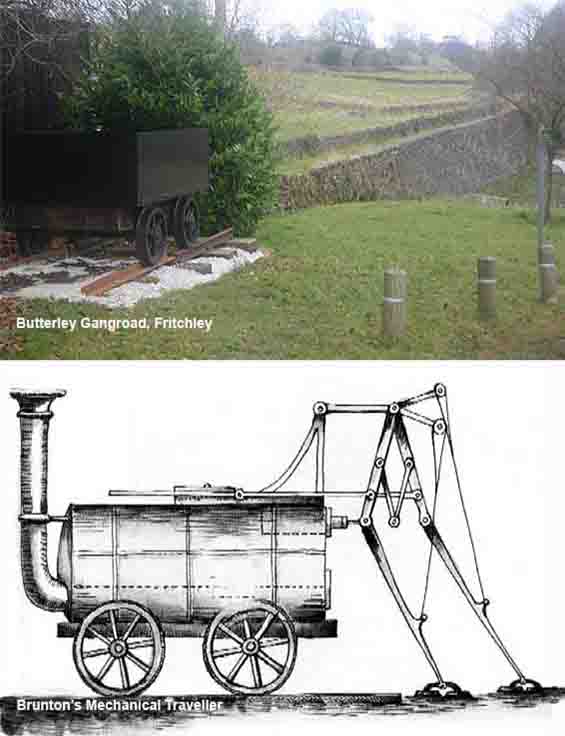
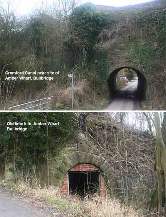
In 1793, forty eight years before Stephenson built his railway from Crich to Ambergate, Benjamin Outram built the Butterley Gangroad, a horse-worked railway that carried limestone down from the Crich quarries to the Cromford Canal at Bull Bridge. From there it the limestone was taken by barge to a tunnel under the Butterley Ironworks at Ripley and lifted up from an underground wharf to furnaces, to help in the making iron. At Fritchley, the gangroad passed under Bobbin Mill Hill through what is now recognised by the Guinness Book of Records as the world’s oldest railway tunnel. Around 1850, sections of the gangroad were re-aligned and the original cast iron plate track was converted to a conventional narrow gauge railway similar to Stephenson’s 1841 railway. The walled embankment running north from the Drying Ground shows the route of one of the re-aligned sections of the gangroad. In 1813, one of the world’s first steam locomotives, Brunton’s ‘Mechanical Horse’, was trialled on the gangroad using metal ‘legs’ to push itself along at 2.5 mph on the steep gradients.
Opened in 1794, the Cromford Canal connected Cromford, Ripley, Ironville, and Langley Mill where it connected with the Erewash and Nottingham canals. It was built by William Jessop, assisted by Benjamin Outram, to transport mainly cotton, lead, limestone and coal from the Derwent and Erewash valleys. At Amber Wharf at Bullbridge, Outram’s railway was able to unload limestone into chutes which fed directly into canal barges with specially strengthed bottoms to withstand the shock. From there, the limestone was taken along the canal to Butterley Ironworks, at Ripley and Codnor Park, to help in the making of iron. In addition, a siding from the railway was used to take limestone to the tops of lime kilns, also at Amber Wharf, where it was burnt with coal to a temperature of 900 degrees centigrade to form lime, mainly for agricultural use.
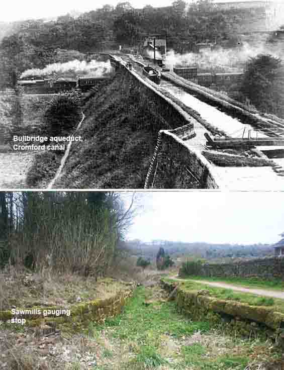
At Bullbridge, there once was a multi-arch aqueduct that was one of the major engineering feats of the building of the Cromford Canal. Originally there were arches to allow access for the main road, the river, a mill leat and Drovers way. In 1840, the railway arch was added to enable George Stephenson’s Derby to Leeds railway to pass under the canal. A huge cast iron tank, made in sections at Butterley Ironworks, was brought along the canal and installed at Bullbridge within 24 hours on a Sunday to avoid disruption to canal traffic. The railway bridge was subsequently dug out beneath the tank.
At the Sawmills Gauging Stop, the canal narrows to enable loaded barges to be ‘gauged’ to determine how much cargo they were carrying and, as a result, how much toll should be paid. A ‘gauging stick’ was used to measure the height of the barge above the water. Using the number of so-called ‘dry inches’ for a particular barge listed in the Trent Navigation Gauging Tables, the toll collector could work out the weight of the cargo and its toll; the heavier the cargo, the lower the barge sat in the water with fewer ‘dry inches’.
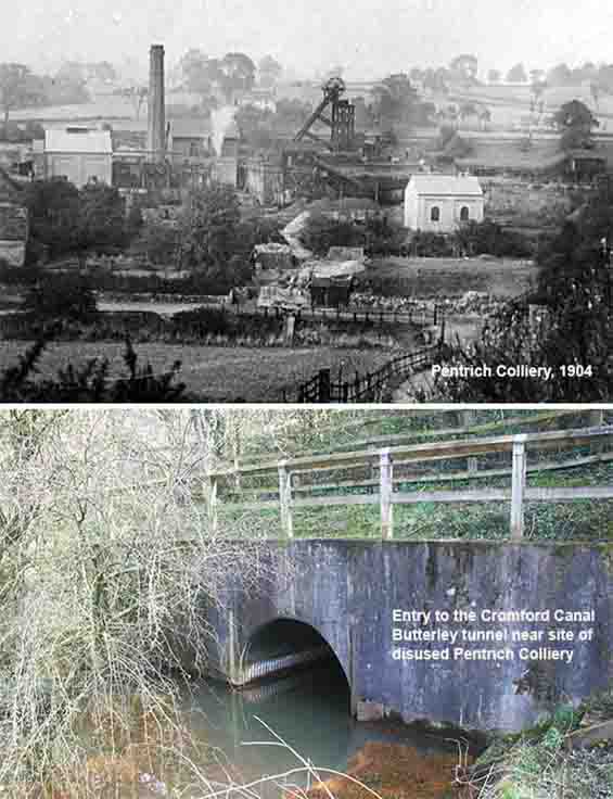
From the late nineteenth century, until 1946 when it ceased production, Pentrich Colliery was owned and run by W C Haslam. The photograph of Pentrich Colliery, taken in 1904 in the direction of Pentrich, shows a very rural setting. But in the opposite direction, towards Ripley, the scene would have been very different: Egerton’s cotton Mill, Butterley Ironworks, a gas works, two major Midland Railway systems, two industrial rail sidings, and a busy Cromford canal wharf, were all very close by.
At the side of Pentrich Colliery, the Cromford Canal entered the Butterley tunnel and 800 hundred yards in, an underground wharf enabled material to be raised directly up to the blast furnaces at the Butterley Ironworks. The tunnel, which was almost two miles long, partially collapsed and, in 1909, it was declared unusable. However, the Hammersmith to Cromford section of the canal continued working until the 1940s, principally for transporting coal from Pentrich Colliery to Cromford.
6. Where the towpath ends, you bear left onto a footpath between the site of the old Pentrich colliery on your left, now Geeson’s haulage yard, and the A38 embankment on your right. At the end of the path, turn right and walk down Asher Lane, passing on your left what used to be Egerton’s Cotton mill, and the newer buildings of the business park. Walk through the village of Hammersmith until you reach the bridge with the Ripley by-pass above you. Just after the bridge, take the footpath to the right and follow it around, keeping to the left of the old railway embankment, until the path joins an old railway cutting. The cutting passes under two road bridges before leading to Outram Street in Ripley and what is now known as the Ripley Greenway. Turn right onto Outram Street, and at the top of the street turn left onto Butterley Hill and walk up into the centre of Ripley.
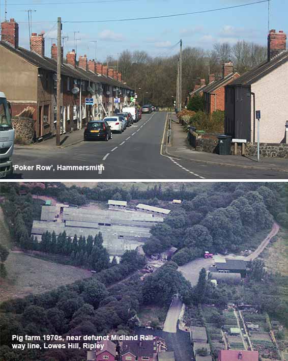
The terraced houses in Hammersmith, known locally as ‘Poker Row’, were built by the Butterley Company to house some of their workers. It was said that a tenant saw the rent man from Butterley Company coming to collect the rent money, they would bang on the adjoining house walls with a poker, sending a message down the street to the other tenants to lock their doors until he went away. The southern-most section of the old railway embankment and cutting that forms the final part of this walk, was once the site of a mink farm established by Arthur Bates and his wife Mary. Several hundreds of mink were bred each year for the fur to be made into to mink coats and stoles, then much sought-after items of luxury clothing. In the mid-1960s, mink farming on the site ended and the pig farm established a few years before was expanded, as shown in the photograph opposite.