About this walk
The walk starts from the bus stop at the top of Brookside Road, Breadsall Hilltop, on the A608 main Derby to Heanor road, and continues along the Great Northern Greenway to Chester Green in Derby, then along the River Derwent into Derby City centre and then further along the river to Wilmorton on the outskirts of Derby. However, the start and finish points are interchangeable, and can be reached by regular buses from Derby City centre.
The overall route covers just under eight miles, some through Derby’s historic city centre, and most of it off-road along the Great Northern Greenway and along the River Derwent. There are seven pubs featured en-route, serving good cask ales; so, at nearly eight miles, it’s a comfortable three or four-pint walk, allowing you to arrive home calorie neutral and none the worse for wear. The pubs are: at Breadsall Hilltop, the Windmill and the Paddock; at Chester Green, the Little Chester Alehouse; at Derby, the Furnace, the Exeter Arms and the Brunswick; and at Wilmorton, the Navigation Inn. Several other good pubs are available in Derby.
As well as the good ale, there are also along the way a number of points of local and historical interest. These include: the Great Northern Railway’s Derbyshire Extension; the old Derby race course; the ancient Roman settlement at “Little Chester”; Bonnie Prince Charles’ entrance and flight from Derbyshire; the renovation of Railway Terrace and the Brunswick Inn; and the Derby Canal.
The route description
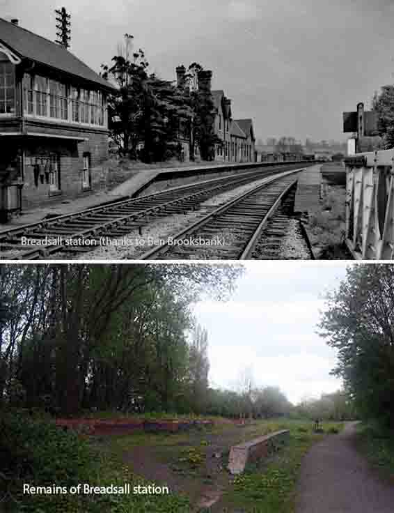
1.The walk starts from the bus stop at the top of Brookside Road, Breadsall Hilltop, on the A608 main Derby to Heanor road. From the bus stop, walk in the direction of Derby and cross the top of Brookside Road. Less than a hundred yards past Brookside Road, take the path off to your right to join the Great Northern Greenway formed from a dismantled railway. Just over six hundred yards further on, the Greenway is bisected by a path which connects Breadsall village with Breadsall Hilltop. Turn left here, off the Greenway, and walk steeply uphill for three hundred yards to the main A608 with the Windmill pub off to you right. From the Windmill, retrace your steps down the path and then turn left to re-join the Greenway. Just over five hundred yards along the Greenway, you will pass the remains of Breadsall village railway station. From the old Breadsall station, continue along the Greenway for three quarters of a mile until you reach the A608 main road and the Paddock pub off to the left.
The Great Northern Greenway is formed from part of the now dismantled Great Northern Railway’s (GNR) Derbyshire extension which was completed in 1877 to enable the GNR to compete with the rival Midland Railway company in getting access to local coal resources. This section of the Derbyshire Extension ran from Awsworth, to Ilkeston, to West Hallam and Stanley Village, before descending to Breadsall. From Breadsall, the line crossed the Derwent valley by a succession of viaducts and embankments before crossing the river, at Handyside Bridge, and on to Friar Gate Station in Derby. The station at Breadsall included a two-storey station master’s house, a signal Box, and single storey buildings. Passenger services from the station finished in 1953 and all services ended completely on the line in 1968.
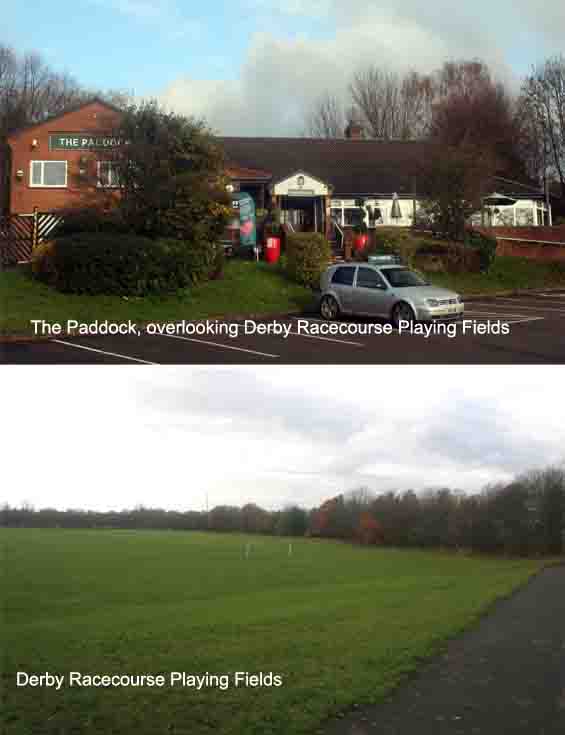
2.Turn left onto the A608 and, just under a hundred yards along the main road, cross over at the pedestrian crossing and bear right down Old Mansfield Road. Walk two hundred and fifty yards down Old Mansfield Road and then take the footpath off to the right. Follow the footpath for just over a quarter of a mile, through a wooded area, until you reach Hampshire Road. Cross over the road and continue walking along the path with playing fields to your left on ground which was once part of Derby Racecourse. After just over a quarter of a mile along the path, turn right and walk under the bridge with the main road overhead. Some eighty yards further on, cross Stores Road and continue down the path walking under the railway bridge with the main Derby to Leeds railway line above. From the railway bridge, continue into Cut Lane which then leads into Caesar Street. At the end of Caesar Street, turn right and walk along Mansfield Road, past Chester Green on your left, until you reach the Little Chester Alehouse on the opposite side of the road at the top of Chester Green Road.
The Derby Racecourse opened in May 1848 on land between Little Chester and Chaddesden. A grandstand was built in 1852 and, in 1856, the Midland Railway opened Nottingham Road station to provide access to the course. In 1863, at the southern end of the course, the South Derbyshire Cricket Club constructed a cricket ground which later became known as the County Cricket Ground after the Derbyshire County Cricket Club started playing there in 1871. The original grandstand was replaced in 1911 by a larger building with a distinctive domed roof and, like its predecessor, the stand served spectators for cricket as well as racing. The final race meeting at Derby took place on 9 August 1939. Following the outbreak of the Second World War, the racecourse was taken over for military use by the Royal Artillery, and anti-aircraft guns were positioned on the site. Following the closure of the racecourse, the land was retained by the council for public recreation and partially converted into football pitches. The area is still known as Racecourse Park.
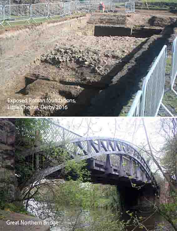
3. From the Little Chester Alehouse, turn right and walk to the bottom of Chester Green Road with the Green on your left. At the bottom of the road, turn right and, after a few yards, cross the road and bear left into the car park. At the bottom of the carpark, take the steps over the flood defence system, and follow the path that takes you over Handyside Bridge with the River Derwent below. Having walked over the bridge, turn right and walk down the steps to join the river path. Continue along the river path for two hundred yards where you will reach the Furnace Inn off to the right. From the Furnace Inn, re-join the river path and, walking under St Mary’s Bridge and then the Derby Inner Ring road, walk for a further three hundred yards to reach the Silk Mill. Walking past the Silk Mill, Cathedral Green and the statue of Bonnie Prince Charles, continue on the river path until you reach Exeter Bridge. Turn right to walk over the bridge, with the River Derwent below, and then cross over the road to Exeter Place at the bottom of which is the Exeter Arms.
Little Chester, or Chester Green as it is more commonly known, was once the site of a Roman town. The Romans set up a fort in AD50 at Strutt’s Park, to protect the river crossing on the western side of the Derwent, before later establishing a larger fortified settlement, across the river at Little Chester, which they called Derventio. Little evidence of Roman occupation remains at Little Chester today, apart from two Roman wells, one on Marcus Street and the other in the garden of the vicarage of St Paul’s Church. In the 1970’s, evidence of further Roman settlement was discovered on Derby Racecourse, consisting of a road, twenty-five foot wide, lined with timber buildings, two pottery kilns and a cemetery. Handyside Bridge was named after Andrew Handyside and Company, the iron founders in Derby that built it. The bridge is part of the Derwent Mills World Heritage Site and now has Grade II listed status.
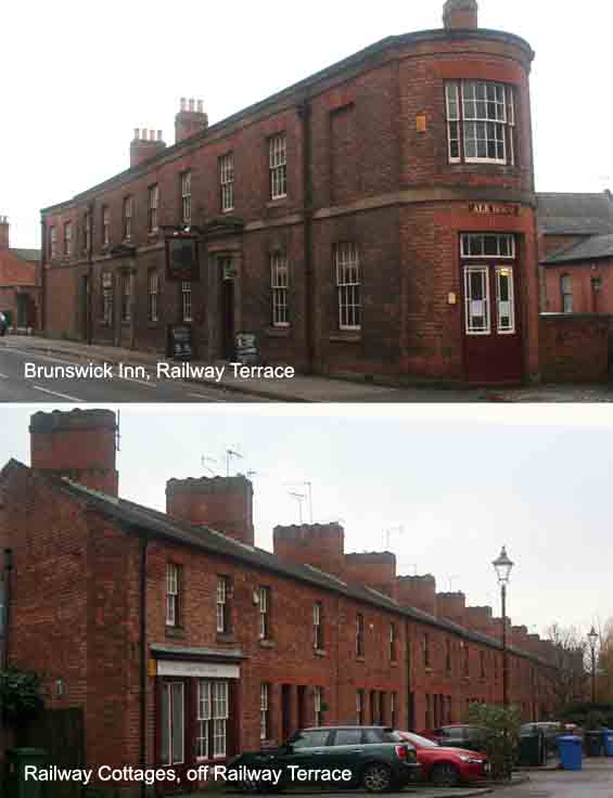
4. From the Exeter Arms, retrace your steps to walk back over the river bridge and then immediately bear sharp left, down the steps, to re-join the river path. Continue along the river path for just over half a mile until you reach a footbridge over Mill Fleam where it joins the Derwent. A hundred and fifty yards after the Mill Fleam bridge, bear left, off the river path, and walk under the flyover to join Railway Terrace where you will see the Brunswick Inn in front of you on the opposite side of the road. From the Brunswick Inn, retrace your steps and continue along the river path, keeping the river close by on your left. After one and a third miles, pass under the main railway line and just over a hundred yards further on, bear right to leave the river path and walk towards Alvaston Park Lake which you will see off to your left. Walk past the lake and, when you come to Alvaston Primary School, take the right turn and walk for just over three hundred yards along the path, bearing left, until you reach the A6 London Road in Wilmorton where there is a regular bus service into Derby city centre. Turn right onto London Road and a hundred yards further on you will reach the Navigation Inn.
The Brunswick Inn was built in 1841 by the North Midland Railway Company, together with a local store and eighty workers cottages said to be the oldest railway cottages in the world. The area was designed and built to be a self-contained community, and the Inn traded continually as a public house until 1974. It was then shut and left to fall into disrepair and, together with the cottages, was marked for demolition. Pressure from the public caused the local council to reconsider the decision to demolish and the Derby Historic Buildings Trust was able to buy the buildings for renovation. The Historic Buildings Trust was unable to complete the renovation due to lack of funds and local businessmen, seeing the potential of the Brunswick, acquired it and were able to reopen it as a public house in 1987. The Navigation Inn at Wilmorton was built around 1798 at the side of the Derby Canal. The canal was completed in 1796 and ran fourteen miles from the Trent and Mersey Canal at Swarkestone to Derby and Little Eaton, and to the Erewash Canal at Sandiacre.