About this walk
The walk described below starts at the Hurt Arms in Ambergate on the main A6 between Derby and Matlock. The walk continues along the old Cromford Canal to Whatstandwell, before climbing up to Wakebridge, just outside of Crich, and then on to the villages of Lea and Tansley before finishing in Matlock. Between Tansley and Matlock, there is an optional extension to the route via the waterfalls and historic mills at Lumsdale. The start and finish points are interchangeable, with good bus services from Derby and Nottingham, and a train service from Derby.
The overall route covers nine miles (or nine and a half miles if you follow the extension to Lumsdale Falls) following part of the Cromford Canal towpath, some steep hills, undulating footpaths and some short distances by road. There are four pubs featured en-route, serving good cask ales; so, at nine miles, it’s a comfortable four-pint walk, allowing you to arrive home calorie neutral and none the worse for wear. The pubs are: The Hurt Arms at Ambergate; The Jug and Glass at Lea; The Tavern at Tansley; and J D Wetherspoon’s The Crown at Matlock. Several other good pubs are available at Matlock.
As well as the good ales, there are also along the way a number of points of historical interest. These include: The Cromford Canal, Crich Stand, St John the Baptist Church at Dethick, Riber Castle, and the Lumsdale Falls and Mills.
- From the Hurt Arms, walk up the main A6 for just under three hundred yards then, on the right-hand side of the A6, turn right up Chase Road. Two hundred yards along Chase Road, just before the canal bridge, bear left to join the canal footpath. Walk one and three quarters of a mile along the towpath to Whatstandwell. From Whatstandwell, continue along the towpath for just under a quarter of a mile and take the footbridge over the canal. Over the footbridge, bear left and follow the path through the wood and, at the public footpath sign to Wakebridge, cross over the lane and continue on the path. As you walk steeply uphill through the wood you will pass several disused quarries on your right. Continue on the footpath past the quarries, and after a few hundred yards you will leave the wood to enter a field. Follow the footpath along the edge of the field until you reach a stile leading to the main Crich to Holloway Road. Bear left at the road and cross over to the other side. Just before the bend, at the footpath sign to Dethick, take the stile and follow the footpath uphill until it joins a farm track with Wakebridge farm on your right. Also on your right, high up in the distance, you will see Crich Stand, the memorial to the Sherwood Foresters.
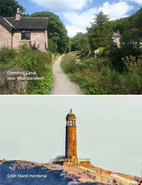
The construction of the Cromford Canal by William Jessop and Benjamin Outram, partners in the Butterley company, was completed in 1794. It is 14.5 miles long and joined Cromford with the Erewash Canal at Langley Mill. It was last used as a working waterway in 1944. Today, the canal is a Site of Special Scientific Interest from Cromford to Ambergate, and the two-mile southern section from Whatstandwell Bridge to Ambergate is a Local Nature Reserve. The canal is a haven for water vole, a threatened and declining species, and for grass snakes, little grebes, moorhen and coots. The stone tower, known as Crich Stand, which stands at over a thousand feet above sea level overlooking the stone quarries at Crich, was completed in 1923 as a memorial to the soldiers from the Sherwood Foresters Regiment who died in World War I.
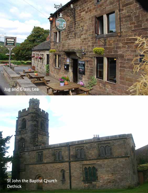
2. Follow the track from Wakebridge Farm to the top of the hill and, two hundred yards further on, take the footpath off to the left across two fields. The footpath then crosses High Lane and continues over several more fields until you will reach a sunken track which is sign-posted ‘Public footpath to Upper Holloway’. Bear right here, and less than a hundred yards down the sunken track, take the stile and footpath off to your left. Cross two more fields and then bear left to continue along a minor road until you reach Lea Main Road where you will turn left and continue on the main road for just over three hundred yards to the village of Lea and the Jug and Glass pub. From the Jug and Glass, retrace your steps one hundred and fifty yards back along the main road and, through the kissing gate, take the footpath off to the left into Swinepark wood. Follow the footpath through the wood and exit into the field, where you will bear left downhill to the gate and then uphill to Dethick church. Exit the church grounds at the rear of the church and, from Manor farm, walk down to Dethick Lane.
The church at Dethick was built in the early 13th century as a private chapel to Dethick Manor. The outward appearance of the original building is well preserved and unaltered, except for additions made in 1532 when Sir Anthony Babington enlarged the chapel to its present size. The height of the building was raised, incorporating the clerestory windows beneath a much flatter roof. In addition, a tower was added at the west end. The most notable family to be associated with Dethick are the Babingtons of Dethick Manor. Sir Anthony Babington was sentenced to death for his part in the plot to free Mary Queen of Scots from imprisonment by her cousin Elizabeth I of England. Another notable family are the Nightingales, who were substantial landowners in the area and spent the summers there. Florence Nightingale, said to be the founder of modern nursing, stayed at Lea Hurst, and, during the 1880s, nursed her mother and rendered charitable work in the communities of Lea, Holloway and nearby Whatstandwell
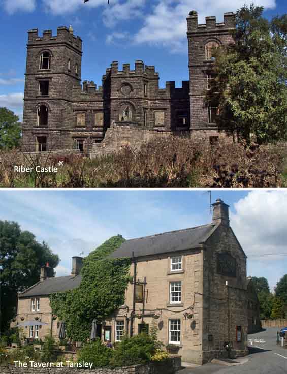
3. Cross over Dethick Lane to take the footpath that leads uphill along the edge of five fields at the top of which you will see Riber Castle off to your left in the distance. In the fifth field, bear slightly right away from the edge of the field and, at the stile, bear right along the rough track until you reach Cunnery Lane. Turn left and walk just over a hundred yards down Cunnery Lane where you will take the footpath off to the right. After four hundred yards through two fields, you will reach a stile that takes you past a house with a monumental standing stone, Leaway, at the top of Starth Lane. Cross over the top of Starth Lane and, at the stone stile, follow the public footpath down to Thatchers Lane at the bottom of which you will reach the Tavern at Tansley on the outskirts of Tansley village. From the Tavern at Tansley, walk along Holly Lane that runs between the pub and its car park, until you reach Church Street in Tansley. Turn right here, walking along Church Street, past the Methodist chapel on your left, until you reach Tansley House Gardens. Cross over the junction and take the footpath to your left. Continue straight ahead down the footpath, ignoring the left fork in the path. Just over two hundred yards further on you will reach the Old Coach Road.
Riber Castle is a 19th-century Grade II listed country house overlooking Matlock. Known locally as ‘Smedley’s Folly’ because of the difficulty of getting water to the hill summit, it was built by the industrialist John Smedley in 1862 as his private home. It is built of gritstone from a local quarry which was pulled up the 660 foot hill by a series of pulleys. After the death of Smedley’s wife, the castle has been used for a variety of purposes including a boys’ school, a site for food storage during World War II, and a wildlife park. More recently it has been converted into a series of apartments. Tansley is recorded in 1086 in the Domesday Book as Taneslege. The village grew during the Industrial Revolution, its main industry being the quarrying of millstone grit for making mill-stones. The water that runs off Tansley moor feeds into Bentley Brook, and three of its feeder streams have been dammed in the past to make artificial lakes which provided water to power mills. As well as the mills in Lumsdale there were also three mills in Tansley village, two of which remain having been restored for new uses. The water also led to the establishment of Tansley Hydro (now Tansley House residential adult care home) when spas and hydrotherapy were in fashion in Victorian times.
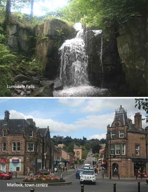
4. At the Old Coach Road, turn left down the road, past Speedwell Mill, and a few yards further on, just before Scholes Mill, take the footpath off to your right keeping the mill pond to your right. Follow the path, past the mill pond, across the foot bridge over the stream and continue along the path passing Tansley Wood Scout Centre on your left. A few yards further on, the path bears right and takes you through open fields where you will see a large disused mill in the distance over to your left. Follow the path until you reach the road at Lumsdale. If you wish to explore the Lumsdale falls and the associated mill complex, turn right at Lumsdale with the top of the falls some four hundred yards uphill. If you wish to take the route directly into Matlock, turn left at Lumsdale and walk down the road for one hundred and fifty yards, past more disused mill building on your left. Just after the sign for Hurst Farm Estate and Matlock, take the turning to the right, and follow the footpath around to the left. Follow the footpath past the recreation ground on your right, past the restored converted mill buildings on your left, until you reach Butts Drive. Turn left onto Butts Drive at the bottom of which you will turn right onto the main Matlock Road. Walk along the main road for just over half a mile, past the river gardens on your right, and into the town centre and J D Wetherspoon’s The Crown. Buses for Alfreton, Ripley, Belper, Derby and Bakewell stop outside The Crown.
The working of mills in the upper part of the Lumsdale Valley was at its peak in the mid-19th Century, but there is evidence of industrial use many years before that – possibly as early as the 1600’s. Powered by water from the Bentley Brook, the mills had various uses over the years, including cotton spinning and bleaching, and grinding corn, bone and minerals for paint manufacture. Soon after industrial use of the site finished, in the 1930s, it was purchased by Arthur Mills and inherited in 1964 by his widow Marjorie whose passion for Lumsdale ensured its survival. Despite many offers for the building stone, she refused to permit demolition of the mill structures, preferring to keep them as they were. Following her death in 1996, ownership of this part of the valley, and responsibility for its preservation, passed to the Arkwright Society.